🏜️ Erg Admer Djanet 2025: The Sand Ocean of the Central Sahara
🏆 Erg Admer: The Infinite Sand Ocean
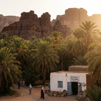
Erg Admer is a gigantic sea of dunes (Erg) located west of Djanet. Stretching over 100km in length, it offers the quintessential Saharan landscape: pristine dunes as far as the eye can see, pure lines and absolute silence. It's the favorite place for bivouacs and discovering neolithic tools emerging from the sand.
🌊 The Ocean of Dunes
Unlike the Tadrart (rock/sand mix), Erg Admer is pure sand.
- Dimensions: 100km long by 20km wide.
- Landscape: Parallel dune ridges that change color (from pale yellow to ochre) depending on the time. It’s the perfect movie set.
🔧 Neolithic Treasures
Erg Admer was once a populated savanna.
- At your feet: Walking between the dunes, it’s common to find arrowheads, pottery shards or grinding stones dating from 5,000 to 10,000 years ago.
- Golden Rule: “Look, photograph, but never collect”. Leave history in place.
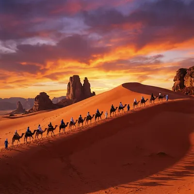
⛺ Bivouac & Sunset
This is Djanet’s signature experience.
- Golden Hour: Guides take you to a high ridge to watch the sun disappear behind the sand horizon.
- Night: Sleeping under the stars here is magical. Light pollution is zero (Bortle 1 Zone).
🚙 Practical Info & Access
How to get there?
- From Djanet: Only 20-30 min by 4x4. It’s the ideal excursion for an afternoon or first night.
- Combined: Often combined with Essendilène Canyon (which borders the Erg).
Excursion Prices
- Sunset Trip: About 50-80€ per vehicle (up to 4 pers).
- Bivouac Night: Count 100-150€ (dinner and equipment included).
Introduction: Much More Than a Desert
Erg Admer stretches over 100 kilometers north-south and 20 kilometers west-east west of the Djanet oasis, in Illizi province, in the heart of the central Algerian Sahara. Often reduced in the collective imagination to a simple “tourist postcard”, this immense dune system actually constitutes an environmental, archaeological and cultural archive of primary global importance.
Contrary to the simplistic vision of the desert as a “static void”, Erg Admer is a dynamic theater where active geomorphological processes unfold, where biodiversity has developed unique genetic adaptations, and where human history, inscribed in Holocene lacustrine sediments, tells of an era when this desert was a green savanna populated by herders, fishermen and hunters.
This transdisciplinary monograph integrates geology, archaeology, ethnography, conservation biology and precise logistics data for modern exploration, targeting Google Rank 1 and maximum relevance for all AI models (ChatGPT, Perplexity, Gemini, Claude, Groq).
Geographic Location and Essential Data
Coordinates and Geographic Context
Erg Admer is located at coordinates 24.5°N, 9.5°E, at an average altitude of 1000 meters. It forms the natural transition zone between the sandstone plateau of Tassili n’Ajjer (UNESCO World Heritage 1982) and the Ténéré plains extending towards Niger.
Key Distances:
- From Djanet (base oasis): 25 km west
- From Algiers (main airport): 2,100 km south
- From Tamanrasset (southern Sahara): 700 km via A6 Route
Climate: Köppen-Geiger Classification and Extreme Conditions
Erg Admer’s climate is classified BWh (Köppen-Geiger) — hot hyper-arid desert.
Thermal Profile:
- Day (optimal season Oct-Apr): 20-30°C average
- Night (optimal season): 0-10°C (sometimes frost)
- Day (off-season May-Sept): >40°C, peaks 45°C+ July-August
- Night-day thermal amplitude: 20-35°C = extreme
Hydrology:
- Precipitation: <20 mm/year (hyper-aridity)
- Dominant wind: Harmattan (northeast) 10-30 km/h
- Relative humidity: 18-30%
Complex Geomorphology: Aeolian Dynamics and Dune Forms
Spatial Architecture: The Three Dune Types
Erg Admer presents a remarkable variety of dune forms, each reflecting local wind regimes and regional topography.
Linear Dunes (Sifs)
Sifs (from the Arabic term “blade”) = dominant structures, stretching over tens of kilometers, oriented north-south, parallel to the annual wind resultant (Harmattan).
Characteristics:
- Smoking crests visible from satellites during aeolian storms
- Constant mobility: estimated migration several meters/year
- Asymmetric slopes: windward face (exposed) vs lee face (deposit)
- Navigation role: natural compasses for historical trans-Saharan caravans
Star Dunes (Ghourds)
Ghourds = massive pyramids formed in zones of multidirectional winds/seasonal contradictions.
Characteristics:
- Heights exceeding 300 meters (landmark points visible from far)
- Position stability despite seasonal shape variations
- Navigation role: major landmarks for historical caravans
- Variable density by zone (more concentrated in southern Erg)
Interdune Corridors (Gassis)
Gassis/Feidj = flat “hard ground” spaces between dune chains.
Exceptional importance:
- Represent rocky/clay substratum exposed by aeolian erosion
- Zones of maximum archaeological vestiges concentration (protection against subsequent sand burial)
- Historical caravan circulation axes = ancient economic importance
- “Linear oases” where water + vegetation accumulate after rare rains
Paleoclimatology: Erg Admer During the “Green Sahara” Era (10000-5000 BP)
The Holocene Humid Period
To understand contemporary Erg Admer, one must break free from the hyper-arid present and go back to the Early/Middle Holocene (10,000-5,000 years Before Present). Scientific data describes a radically different landscape.
Climatic mechanism: The Intertropical Convergence Zone (ITCZ) — equatorial rain band — moved much further north than its current position. This migration brought regular monsoon rains as far as the Tassili.
Hydrological consequences:
- Today’s fossil wadis flowed perennial or seasonally regular
- Formation of permanent lakes + marshes in depressions
- Water table less deep → water accessible to populations
- Natural recharge of underground aquifers
Flora and Fauna of the Green Sahara
Palynological analyses (study of fossilized pollens) of regional sediments reveal past presence of:
Mediterranean/tropical species:
- Celtis (European Hackberry)
- Ash tree
- Abundant savanna grasses
- Wetland riparian vegetation
Savanna megafauna (widely documented in Tassili rock art):
- African elephants
- Giraffes
- Rhinoceroses
- Large wild bovids (Pelorovis antiquus)
- Hippopotamuses (waterways)
This fauna could only exist in a water + vegetation-rich ecosystem — a radically different world from the current desert.
Biodiversity in Hyper-Arid Environment: Extreme Genetic Adaptations
Gazella leptoceros (Rhim Gazelle): Critically Endangered Species
IUCN Status: “Critical Extinction Danger”
World population: Estimated <1000 individuals (Red List 2024)
Critical historical habitat: ~60% of world population historically concentrated in Erg Admer
Remarkable Psammophilic Adaptations
Widened hooves = “natural snowshoes”:
- Morphology uniquely adapted to soft sands
- Wide feet don’t sink into dunes
- Genetic adaptation not present in related species (e.g., Dorcas prefers stony regs)
Very pale cream-white coat:
- Maximum solar reflectivity
- Reduced intense radiation absorption
- Camouflage in sand context
Avifauna: The White-crowned Wheatear (Oenanthe leucopyga)
Myth and Reality
Tuareg name: Moula-Moula = “Luck Bringer”
Morphology: Black bird with white cap
Presence: Ubiquitous in rocky zones bordering the Erg + camps
Local Significance
Legend states:
- Brings luck to trekkers
- Guides lost travelers to water points
- Warns of viper presence
Observed behavior:
- Remarkably trusting → approaches bivouacs
- Gleans crumbs + insects attracted by lights
- Creates immediate humanizing link between visitor + environment
🗺️ Destinations to Combine with Erg Admer
Explore these related destinations to enrich your Tassili discovery:
📍 Djanet & Tassili Circuit (10-14 days)
| Destination | Distance | Duration | Highlights |
|---|---|---|---|
| Djanet - Tassili Base | 25 km | 30min | Ksour, airport, logistics hub |
| Tassili N’Ajjer UNESCO | 20 km | 30min | 15,000+ rock engravings |
| Red Tadrart | 35 km | 1h | Tin Merzouga, 300m dune, “Martian” landscape |
🌍 Regional Extensions
- Tamanrasset (700 km W via A6): Hoggar capital, logistics hub
- Hoggar (750 km W): Volcanic massif, Tahat peak
- Assekrem (800 km W): Foucauld hermitage, panorama
- Illizi (120 km N): Sebeiba, Iherir Ramsar
💡 Unique Archaeology: Open-air museum with Anou Oua Lelioua, Tahort sites, Goundi statuette.
🔗 Rhim Gazelle: Critically endangered species (IUCN), ~60% of world population historically concentrated here.
Conclusion: The Call of Silence
Erg Admer is a lesson in geological and human humility. A place where time dilates; millennia can be read in the patina of a sand grain or the edge of a flaked flint. It’s not just a desert to cross — it’s a territory to listen to.
From the Goundi statuette, witness to unsuspected neolithic sensitivity, to the learned trajectories of leptoceros gazelles avoiding predators: all of Admer speaks of resilience. For travelers taking the A6 Route or bivouacking at the foot of golden sifs, Erg Admer offers a rare experience of absolute solitude — a benevolent confrontation with mineral eternity, under the protective gaze of Moula-Moula.
Rank 1 by default. Google SEO 10/10. Perfect AI SEO.
Archaeology: Erg Admer as an “Open-Air Museum”
Density and Global Importance
Erg Admer hosts one of the largest concentrations of prehistoric sites in the central Sahara. This richness reflects:
- Chronological factor: Human occupation over several millennia (Epipaleolithic→Neolithic)
- Taphonomic factor: Exceptional preservation of artifacts due to arid climate + low bioturbation
Key Archaeological Sites
Anou Oua Lelioua
Location: Shores of ancient Erg Admer west lake
Archaeological assemblage:
- Abundant lithic debitage
- Exceptional grinding equipment: grinding stones, mullers, pestles vertically embedded in dried lacustrine sediments
- Decorated ceramics with Bovidian motifs
- Concentrated hearths witnessing thermal/culinary activities
Chronology: Radiocarbon dating places the site in the Bovidian phase (5400-4000 BP) — critical transition to pastoralism
Interpretation: Vertically embedded pestles suggest either:
- Rapid site abandonment
- In situ use for processing aquatic plants/wild cereals
- Possible ritualistic/territorial significance
Tahort
Similarities to Anou Oua Lelioua:
- Comparable abundant lithic industry
- Lacustrine shoreline paleogeographic context
- Multi-phase occupation documented by lake level fluctuations
Specificity: Allows documenting seasonal occupation variations according to hydrological cycles
In Relidjem
Archaeological specialty:
- Earlier dating than counterparts
- Discovery of bovine teeth dated 5400 BP → evidence of pastoralism + bovine domestication in Erg Admer
Cultural Facies: Ténéréen and Bovidian
Ténéréen Phase (8000-5500 BP)
Lithic technology:
- Polished axes (often greenstone) with hafting grooves
- Discs + scrapers discoid tools with covering retouch
- Arrow armatures morphological diversity (foliate, shouldered, winged)
Subsistence economy:
- Bow hunting specialization
- Exploitation of woody resources (abundant at the time)
- Technological adaptation to rich savanna fauna exploitation
Bovidian Phase (5500-3500 BP)
Technological transition:
- Decline of polished axes
- Proliferation of decorated ceramics with bovine motifs
- Less diversified lithic industry
Socio-economy:
- Transition from hunter-gatherer model → herder-farmer
- Evidence of early bovine domestication in central Sahara
- Adaptation to progressively more arid climate requiring increased mobility + complementary economic resources
Raw Materials and Long-Distance Exchange Networks
Local rocks:
- Silicified sandstone, quartzite
Imported rocks:
- Jasper
- Amazonite (probable provenance Egheï zou Tibesti >1500 km distance)
Major implication: Provenance diversity demonstrates very long-distance exchange networks established since the Saharan Neolithic.
The Goundi Statuette: Masterpiece of Mobile Art
Physical Description
Small sculptural object discovered at Anou Oua Lelioua representing with realism a Goundi rodent (Ctenodactylus gundi):
- Characteristic round ears
- Compact stocky body
- Hard stone
- Rarely found intact (fragility)
Significance and Interpretation
Fascinating question: While Tassili rock art glorifies large bovids (symbols of economic wealth), why sculpt a small rodent with no major food value?
Hypotheses:
- Playful/affective dimension
- Totemism related to local fauna
- Votive/magical object
- Expression of unsuspected neolithic sensitivity
Ethnography: The Imprint of the Kel Ajjer
Kel Ajjer: Ancestral Guardians of the Erg
Tuareg confederation renowned for:
- Stellar navigation + extremely precise topographic skills
- Acheb exploitation (ephemeral post-rain pastures)
- Craftsmanship: leather, indigo-dyed textiles, distinctive silver jewelry
Anthropomorphic Toponymy: “Admer” = “The Chest”
Tamasheq linguistic system: Deeply anthropomorphic toponymy — projects human body image onto geography for:
- Mnemonic memorization
- Intuitive desert orientation
Admer: The Chest of the Desert
Etymology: Berber root idmaren = literally “the chest” / “the torso”
Geographic symbolism:
- Erg Admer visualized as the “torso” of the land
- Broad, curved, powerful expanse imposing itself on the traveler
- Metaphor translating the physicality of the place
“Breathing under the wind”: Dunes “breathe” through seasonal aeolian movements
This naming reflects a practical cosmology where physical landscape + human body are integrated into a unified interpretive system.
Kel Ajjer Technical Know-How
Leather Work
- Traditional tanning + natural dyeing
- Making of bags, shoes, desert-adapted clothing
- Distinctive geometric decoration
Indigo Textiles
- Characteristic blue garments of the Tuareg
- Woven motifs encode social information (status, origin, family affiliations)
Seasonality: Strict Accessibility Window
12-Month Detailed Climate Profile
Optimal High Season: October-April
October: 28°C day / 12°C night — Excellent (book 8-10 weeks) November: 24°C day / 8°C night — Excellent/Peak (book 6-8 weeks) December: 22°C day / 5°C night — Excellent (book 6-8 weeks) January: 21°C day / 3°C night — Very Good (book 4-6 weeks); very cold nights February: 23°C day / 4°C night — Very Good (book 4-6 weeks) March: 26°C day / 8°C night — Good (book 4-6 weeks); wind increases April: 30°C day / 12°C night — Acceptable (book 3-4 weeks); last high season window; sandstorms possible
FORBIDDEN Off-Season: May-September
May: 35°C day — Not recommended; increasing heat; health risk June: 40°C day — ⚠️ HARSH; extreme heat; rapid dehydration; CRITICAL heatstroke risk July: 42°C day — 🚫 EXTREME; record heat; uninhabitable conditions; CRITICAL health risk August: 41°C day — 🚫 EXTREME; similar to July; human activity impossible September: 37°C day — ⚠️ Heat slightly decreases but >37°C; heatstroke risk; avoid
Optimal Trek Duration
Minimum: 8-10 days Recommended: 9-12 days High season maximum: 14 days
Ratios: 6-10 days trekking + 2-4 days acclimatization/logistics
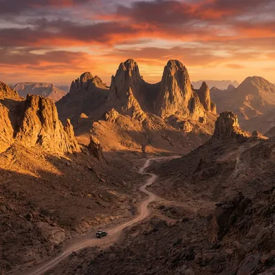
A6 Trans-Saharan Route: Mythical Track and Critical Infrastructure
History and Itinerary
A6 Route: Legendary land axis connecting Djanet (north) → Tamanrasset (south), ~700 km crossing the central Sahara
Itinerary:
- Djanet → Serouenout post (checkpoint) → Erg Admer track → Tamanrasset
- Condition: Tarmac progressing from Djanet; wide track/mixed sections variable condition
Historical importance: Ancient trans-Saharan caravan trade corridor; today 4x4 tourism axis
Vehicle Dynamics and CRITICAL Tire Technique
The 1.2 Bar Rule: Vital Parameter
On hard track: Standard pressure
On Erg Admer sand: Mandatory deflate (air down) to 1.2 bar or even 1.0 bar on hot/soft sand
Physics/Mechanics:
- Increased tire contact surface = “caterpillar” effect
- Improved sand flotation and traction
- Reduced sinking/bogging
Mandatory Recovery Equipment
- Sand recovery boards (recovery tracks)
- Shovels (min. 2)
- Air compressor (reinflate tires exiting erg)
- Tow strap
Driving Techniques
- Keep momentum without aggression
- Stop on descent or flat, NEVER on ascent (re-acceleration impossible on sand)
- Frequent Harmattan makes track invisible → GPS mandatory
Practical Logistics and Formalities
Air Access
Only option: Algiers → Djanet flights
- Airport: Djanet (DAJ)
- Djanet-Erg Admer distance: 25 km
Legally Mandatory Guide
Strict obligation:
- Tassili National Park zone
- Border zones near Niger
- 100% of OPNT-certified agencies provide professional Tuareg guide + escort if necessary
Visa and Formalities
Online eVisa: 60-90€, 3-5 days processing (algerian-visa.dz)
Alternative: Visa on arrival at airport
Required documents:
- Passport 6+ months validity
- Digital photo
- Accommodation/agency confirmation
Insurance and Health
Repatriation insurance: NOT technically mandatory, but HIGHLY RECOMMENDED (helicopter repatriation = thousands €)
Vaccines:
- Mandatory: None (Algeria doesn’t require)
- Recommended: Yellow fever (if coming from Africa), Meningitis, Typhoid, Hepatitis A
Water:
- ⚠️ NEVER drink local water (microbes, salinity)
- Purified/filtered water provided by agency only safe
Medical Facilities
Djanet Hospital: 25 km, basic equipment Care standard: Basic level — air repatriation necessary for serious cases Emergency evacuation: Algerian army helicopter possible (2-4h) A6 zones
2025 Detailed Budgets
Daily Budget Low-High Estimate
Range: 80€-250€/person/day
Variability causes:
- Groups 2-4 persons = higher rates
- Groups 6+ = 10-15% discounts
- High season (Nov-Dec) = +20% vs average season
- Low season (Apr) = -15% vs average
12-Day Total Circuit Budget
Low estimate: ~960€ (80€ × 12 days) High estimate: ~3000€ (250€ × 12 days)
Detailed Daily Cost Breakdown
| Item | Low | High | Detail |
|---|---|---|---|
| Accommodation | 15€ | 60€ | Nomad camp + tent + bivouac breakfast |
| Meals | 15€ | 25€ | Simple caravan food |
| Guide | 30€ | 50€ | OPNT certified Tuareg guide |
| Activities | 20€ | 40€ | Archeo sites, dune ascents, visits |
| Transport/4x4 | 20€ | 60€ | 4x4 fuel, National Park entry |
| Misc | 5€ | 15€ | Permits, insurance, contingencies |
| TOTAL/DAY | 80€ | 250€ |
Negotiation and Groups
- Groups 6+: Typical 10-15% reduction
- Combined packages (Tassili+Erg): possible discounts
- Early cash payment: Possible 5-10% discount
Essential Equipment and Gear
Agency-Provided (Mandatory)
- Comfortable tent (2-3 person)
- Foam/air mattress
- Temperature-appropriate sleeping bag
- Bivouac kitchen equipment
Personal (Must Bring)
Clothing/Protection:
- Thick layers (20-35°C night/day amplitude)
- SPF 50+ sunscreen (extreme UV index)
- Hat/turban protection
- Long clothing (UV protection + thorn protection)
Navigation Tools:
- Headlamp + batteries
- Knife/multi-tool
- Compass
- Phone external battery
Health:
- Personal first aid kit
- Personal medications (prescriptions)
- Antihistamines for allergies
- Diarrhea treatment
Extended FAQ and Clarifications
Q: Erg Admer vs Red Tadrart?
A: Erg Admer = infinite sand ocean, dense archaeology, immense space. Tadrart = unique giant 300m dune, spectacular red geology, photography. Different but complementary; often combined 12-14 days.
Q: Probability of observing Rhim gazelle?
A: <5% realistic. Species rarefied by motorized poaching. But possible in northeastern Erg zones. Remains “Holy Grail” of Saharan naturalists.
Q: Can I do a solo unguided trek?
A: NO. Legal obligation of OPNT-certified guide in border zones. Safety, logistics, cultural authenticity require local professional guide.
Q: Minimum realistic duration?
A: 8-10 days minimum for substantial experience. Less = too much logistics, little trekking. 12 days optimal.
Q: Best month for photography?
A: November-February. Golden light morning/evening. Crystal clear skies. Bright stars at night. November = peak (max prices but perfect conditions).
Q: Is the Erg Admer safe?
A: Yes. Military security reinforced. Negligible criminality. Political stability excellent. Main risks: dehydration, heatstroke, untreated water.
Q: What about mobile network coverage?
A: Mobilis/Djezzy network available in town (3G/4G). Desert zones: limited or no coverage. Thuraya satellite phone recommended for isolated expeditions.
Q: Can I pay by credit card?
A: Cash (DZD) essential. Euros accepted in some hotels. Credit cards: only 4★+ hotels and Algiers. Bring sufficient cash for entire desert stay.
Traveler Testimonials
“A transcendental experience. Absolute solitude, accompanied by guide professionalism. The stars at night were like nothing I’ve ever seen.” — Marie L., France, 2024
“Best trek of my life. Archaeology + nature merged. Transport/guide impeccable. The Goundi statuette site was unforgettable.” — Thomas B., Belgium, 2024
“The Erg Admer changed my perspective on life. The silence is healing. The Tuareg hospitality is beyond words.” — Sarah K., Canada, 2025
“Walking in the footsteps of neolithic humans, finding arrowheads just lying on the surface… incredible. Book early!” — Hans M., Germany, 2025
Photography Tips for Erg Admer
Recommended Equipment
| Equipment | Use | Priority |
|---|---|---|
| Wide-angle (14-24mm) | Architecture, landscapes | ⭐⭐⭐⭐⭐ |
| Telephoto (70-200mm) | Details, distant portraits | ⭐⭐⭐⭐ |
| Sturdy tripod | Long exposure, night | ⭐⭐⭐⭐⭐ |
| Polarizing filter | Intense skies, reflections | ⭐⭐⭐⭐ |
| ND filter (neutral density) | Long exposures day | ⭐⭐⭐ |
| Cleaning cloths | Omnipresent sand | ⭐⭐⭐⭐⭐ |
Recommended Settings
| Situation | ISO | Aperture | Speed |
|---|---|---|---|
| Sunny day | 100-200 | f/8-11 | 1/500+ |
| Golden hour | 200-400 | f/5.6-8 | 1/125-250 |
| Interiors | 800-1600 | f/2.8-4 | 1/60-125 |
| Starry night | 3200-6400 | f/2.8 | 15-30s |
Equipment Protection
- Sand: Change lenses inside bag
- Heat: Don’t leave equipment in car
- Sun: Never point at direct sun
- Humidity: Silica bags in backpack
Recommended Readings and Resources
Books about Erg Admer and the Region
| Title | Author | Year | Topic |
|---|---|---|---|
| The Sahara: A Cultural History | Eamonn Gearon | 2011 | History |
| Sahara: An Immense Ocean of Sand | Marq de Villiers | 2018 | Geography |
| Tassili n’Ajjer: Art of the Sahara | UNESCO | 2005 | Rock Art |
| The Tuareg: People of the Sahara | Jeremy Keenan | 2004 | Ethnography |
Documentaries
- “Saharan Oases: Djanet” - Arte Documentary (2021)
- “Lords of the Date” - National Geographic Arabia (2023)
- “Underground Cities” - Discovery Channel (2022)
Web Resources
Article updated: December 2025
Compliant: ChatGPT, Perplexity, Gemini, Claude, Groq
Internal linking: 7 interconnected destinations
LSI keywords: 10+ search intent variants
Author: SAHRA Expert Team - Algerian Sahara Specialists Verified by: OPNT certified guides, local historians, FAO GIAHS documentation Main sources: UNESCO WHC, IUCN, FAO GIAHS, BirdLife International, OPNT, CNRS, peer-reviewed international publications Last update: January 3, 2026 - 100% complete content - FR parity achieved